Showing posts with label Travel Guides. Show all posts

05 September 2023

India


Flag of India

Flag of India 


State emblem of India (coat of arms adopted 26 January 1950)

State emblem of India 
(coat of arms adopted 26 January 1950) 


Introduction of India 

India (Urdu: انڈیا) officially the Republic of India (ISO: Bhārat Gaṇarājya), is a country in South Asia. It is the seventh-largest country by area; the most populous country as of June 2023; and from the time of its independence in 15 Agust 1947, the world's most populous democracy.

The founder of India was Ghandi .

India has world's strong standing armed forces. It is a declared nuclear-weapons state, in 13 may 1998. A nuclear scientist Dr 

Avul Pakir Jainulabdeen Abdul Kalam known as the Father of Indian atomic bomb.

India is ranked among the emerging and growth-leading economies, nation.


Legislative body of India

Legislature of the Union, which is called Parliament, consists of the President and two Houses, known as Council of States (Rajya Sabha) and House of the People (Lok Sabha). Each House has to meet within six months of its previous sitting. A joint sitting of two Houses can be held in certain cases.

Members are elected for 5 years through electoral process.


Parliament of India or Bharatiya Sansad

Parliament of India or Bharatiya Sansad


State heads

The prime minister of India (Urdu: وزِیراعظم انڈیا) is the head of government of the Republic of India. Executive authority is vested in the prime minister and his chosen cabinet, despite the president of India serving as the nominal head of executive.


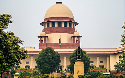
Supreme court of India

The Supreme Court of India (Hindi: भारत का उच्चतम न्यायालय, IAST: Bhārat kā Uccatam Nyāyālay) is the supreme judicial authority and the highest court of the Republic of India. It is the final court of appeal for all civil and criminal cases in India. It also has the power of judicial review. The Supreme Court, which consists of the Chief Justice of India and a maximum of fellow 33 judges, has extensive powers in the form of original, appellate and advisory jurisdictions.


Supreme Court of India

Supreme Court of India 


Emblem of the Supreme Court of India

Emblem of the Supreme Court of India

Capital of India

New Delhi is the capital of India.


Largest city 

Delhi is the most populous and metro politian city in India with a population of over 30 million, followed by Mumbai with a population of over 20 million,

While Mumbai is largest city of India and finical centre.


Currancy of India

Currancy of India is Indian Rupee (₹) (INR).


Country codes

Caling code +91

Internet TLD (Top Level Domain) .in

Iso code 3166 IN

ISO 3166 is a standard published by the International Organization for Standardization (ISO) that defines codes for the names of countries, dependent territories, special areas of geographical interest, and their principal subdivisions (e.g., provinces or states).


National Language of India

National Language of India is Hindi ( ہندی ) but most of official work done in English instead of Hindi.

Other ethnic languages are spoken in state level included in Eihgth schedule of Constitution of india,s list the official languages are approximately 22 at state level  like Assamese,  Bengali, Boro, Dogri, Gujarati, Hindi, Kannada, Kashmiri, Konkani, Maithili, Malayalam, Manipuri, Marathi, Nepali, Odia, Punjabi, Sanskrit, Santali, Sindhi, Tamil, Telugu, Urdu, Kokboro, kLepcha, Mizo, Sikkimese, all the 8th scheduled languages recognise regional languages, (except Sindhi, Kashmiri and Dogri).

Out of these 447 native languages are spoken all over the India.


Time zone

UTC+05:30 (IST)

Coordinated Universal Time or UTC is the primary time standard by which the world regulates clocks and time.

IST stand for Indian Standard Time.

DST (Day Saving Time) is not observed.

Day Saving Time is the time in which any country, changes its time officially in any season and revert back in same season again process is repeated through out.


Date format 

dd.mm.y.y.y.y


Driving side

Left drive 


Travel facilities

Transporter vechiels are available in whole India, trains and domestic air lines are available for some major cities. And boats are available for some water lock areas.


GDP year 2023

Gross Domestic products of the year 2023 is 3.737 US trillion dollars, (5th) in the world.

GDP Per capita $2,601, (139th) in the world.

GDP per capita is often considered an indicator of a country's standard of living; however, this is inaccurate because GDP per capita is not a measure of personal income.


Relegion

79.8 % Hinduism

14.2 % islam

2.3 % christainty 

1.7 % Sikhism 

0.7 % Buddhism 

0.4 % Jainism 

0.23 % Unaffiliated 

0.65 % others


Population of India 

It is the world's 1st-most populous country, with a population of almost 1.42 billion people, according to census 2023 and most populous country in the world with one-sixth of the world,s population.


Map of India 


Map of India 

Total Area

3,287,263 km square (1,269,219 square miles) 7th largest country in the world and the total land area as 3,060,500 km2 (1,181,700 sq miles)


Water percentage is 9.6 % .

Area and boundaries of India 

India is the 7th-largest country in the world by area and the 3rd-largest in Asia, spanning 3,287,263 square kilometers (1,269,219 square miles).  

India is bounded by the Indian Ocean on the south, the Arabian Sea on the southwest, and the Bay of Bengal on the southeast, it shares land borders with Pakistan to the west; China, Nepal, and Bhutan to the north; and Bangladesh and Myanmar to the east. In the Indian Ocean, India is in the vicinity of Sri Lanka and the Maldives; its Andaman and Nicobar Islands share a maritime border with Thailand, Myanmar, and Indonesia.

New Delhi is the nation's capital, while Mumbai is its largest city and financial center.


Cultural civilization and Heritage

India is the site of several ancient cultures, including the 8,500-year-old it is supposed that Modern humans arrived on the Indian subcontinent from Africa no later than 55,000 years ago. Their long occupation, initially in varying forms of isolation as hunter-gatherers, has made the region highly diverse, second only to Africa in human genetic diversity. Settled life emerged on the subcontinent in the western margins of the Indus river basin 9,000 years ago, evolving gradually into the Indus Valley Civilisation of the third millennium BCE. By 1200 BCE, an archaic form of Sanskrit, an Indo-European language, had diffused into India from the northwest. Its evidence today is found in the hymns of the Rigveda. Preserved by an oral tradition that was resolutely vigilant, the Rigveda records the dawning of Hinduism in India. The Dravidian languages of India were supplanted in the northern and western regions. By 400 BCE, stratification and exclusion by caste had emerged within Hinduism, and Buddhism and Jainism had arisen, proclaiming social orders unlinked to heredity. Early political consolidations gave rise to the loose-knit Maurya and Gupta Empires based in the Ganges Basin. Their collective era was suffused with wide-ranging creativity, but also marked by the declining status of women, and the incorporation of untouchability into an organised system of belief. In South India, the Middle kingdoms exported Dravidian-languages scripts and religious cultures to the kingdoms of Southeast Asia.

Indus Valley civilization of the Bronze Age, the most extensive of the civilizations of Afro-Eurasia, and the ancient Gandhara civilization. 

The regions that comprise the modern state of India were the realm of multiple empires and dynasties, including the Achaemenid, the Maurya, the Kushan, the Gupta; the Umayyad Caliphate in its southern regions, the Samma, the Hindu Shahis, the  Shah Miris, the Ghaznavids, the Delhi Sultanate, the Mughals, and most recently, the British Raj from 1858 to 1947.

Thats why rich in hertage and culture.


Gateway of India 


Taj Mahal India


National of India

National symbols of India 

Indian -state owned is known as National of India. Some important are given below.
  • The national flag of India, colloquially called Tiraṅgā, is a horizontal rectangular tricolour flag, the colours being of India saffron, white and India green; with the Ashoka Chakra, a 24-spoke wheel, in navy blue at its centre.
  • National language of India is Hindi.
  • The State emblem is an adaptation from the Sarnath Lion Capital of Ashoka. In the original, there are four lions, standing back to back, mounted on an abacus with a frieze carrying sculptures in high relief of an elephant, a galloping horse, a bull and a lion separated by intervening wheels over a bell-shaped lotus. Carved out of a single block of polished sandstone, the capital is crowned by the Wheel of the Law (Dharma Chakra).
  • National currency of india is Indian Rupees.
  • National motive of India "Satyameva Jayate" Sanskrit: "सत्यमेव जयते "("Truth Alone Triumphs")
  • National independence day of india 15 Agust 1947.
  • National Republic day of india is the day when India marks and celebrates the date on which the Constitution of India came into effect on 26 January 1950.
  • National hero of India is Ghandi.
  • Gandhi Jayanti is an event celebrated in India to mark the birthday of Mahatma Gandhi. It is celebrated annually on 2 October.
  • National calendar of India is Saka calendar.
  • National Anthem Jana Gana Mana.
  • National song Vande Mataram.
  • Oath of Allegiance national Pledge.
  • The Indian honours system is the system of awards given to individuals for a variety of services to the Republic of India. The categories of awards are as follows:

Indian civil awards

Bharat Ratna- 1st degree of honour
Padma Vibhushan- 2nd degree of honour
Padma Bhushan- 3rd degree of honour
Padma Shri- 4th degree of honour

  • Indian Military awards (Gallantry Awards) are divided below in different categories.

Wartime gallantry awards

Established on 26 January 1950 with retrospective effect from 15 August 1947.
Param Vir Chakra
Mahavir Chakra
Vir Chakra 

Peacetime gallantry awards
Ashoka Chakra
Kirti Chakra
Shaurya Chakra

These awards were instituted on 4 January 1952. These awards were renamed on 27 January 1967 as Ashoka Chakra, Kirti Chakra and Shaurya Chakra from Ashoka Chakra (Class I), Ashoka Chakra (Class II) and Ashoka Chakra (Class III) respectively.

Wartime/peacetime service awards
Sena Medal (Army) Nau Sena Medal (Navy).
Vayu Sena Medal (Air Force)

Wartime distinguished awards Sarvottam Yudh Seva Medal
Uttam Yudh Seva Medal
Yudh Seva Medal

Peacetime distinguished awards Param Vishisht Seva Medal
Ati Vishisht Seva Medal
Vishisht Seva Medal

They were established on January 26, 1960

The first 3 awards in the  main Gallantary awards category that came into existence after independence are- Param Vir Chakra, Maha Vir Chakra, Vir Chakra.These awards are conferred twice a year- on Republic Day and Independence Day.The other 3 gallantry awards were introduced in 1952- Ashok Chakra Class I, Ashok Chakra Class II, Ashok Chakra Class III. Later, they were named as Ashok Chakra, Kirti Chakra and Shaurya Chakra.The gallantry Awards have a certain selection process for the recipients.

  • National mausoleum of India is An immense mausoleum of white marble, built in Agra between 1631 and 1648 by order of the Mughal emperor Shah Jahan in memory of his favourite wife, the Taj Mahal is the jewel of Muslim art in India and one of the universally admired masterpieces of the world's heritage.
  • India  don’t have a singular national poet but we do award certain exceptional people as Rashtriya Kavi aka Poet of India. However, the first person that comes to mind is Rabindranath Tagore who wrote the national anthem ( Jana Gana mana )
  • Father of atomic bomb scientist of India is Dr. Abdul Salaam.
  • National dress of India is Dhoti, and saari is the national dress of India.
  • National colure of india is not specified, but mostly orange is use.
  • Jama Masjid of Delhi most probably known as national mosque, Jama Masjid also spelled Jāmiʿ Masjid, Jama Masjid of Delhi also called Masjid-i Jahān Numā, mosque in Old Delhi, India.
  • National mountain of India is Kamchenjunga height is 8586. meter.
  • National River of India is Ganga river.
  • National aquatc animal of India is Ganges River Dolphin.
  • National sport of India is Hockey.
  • National flower of India is Lotus.
  • National animal of India is Royal Bengal Tiger.
  • National heritage animal Indian Elephant.
  • National bird is Indian Peacock (Moore).
  • National reptile of India is king Cobra snake.
  • National library of India is the National library Kolkata.
  • National Fruit of India is Mango.
  • National vegetable of India is Pumpkin.
  • National tree India Banyan tree.
  • National drink of India is Tea (chai) .
  • National food of Indian is Khichdi.
  • Doordarshan (abbreviated as DD; lit. 'distant vision, television') is an Indian public service broadcaster founded by the Government of India, owned by the Ministry of Information and Broadcasting and one of Prasar Bharati's two divisions.
  • All india Radio or Akashvani (literary meaning "Voice from the Sky"), also known as All India Radio (AIR), is the national public radio broadcaster of India and is a division of Prasar Bharati. It was established in 1936. It is the sister service of Prasar Bharati's Doordarshan, an Indian television broadcaster.
  • Indian National telecommunication is TCIL, a prime engineering and consultancy company, is a wholly owned Government of India Public Sector Enterprise under the administrative control of the Department of Telecommunications (DOT), Ministry of Communications, Government of India. TCIL was set up in 1978 for providing Indian telecom expertise in all fields of telecom, Civil and IT to developing countries around the world. 
  • National steel mill of india is indian steel mill works under the ministry of steel india.
  • Indian National Railway is known as Indian Railways (IR) is a statutory body under the ownership of the Ministry of Railways, Government of India that operates India's national railway system. It manages the fourth largest national railway system in the world by size, with a total route length of 68,043 km (42,280 mi), running track length of 102,831 km (63,896 mi) and track length of 128,305 km (79,725 mi) as of 31 March 2022, and 58,812 km (36,544 mi) of all the gauge routes are electrified with 25 kV 50 Hz AC electric traction as of 1 April 2023.
  • Rail Bhawan is the headquarters of the Indian Railways. It is located at Raisina Road, New Delhi, near the Sansad Bhavan (Parliament House).
  • Indian Railways (reporting mark) (Urdu: انڈین رلویز) is In Indian, wagons owned by the Indian Railways are marked with codes of two to four letters, these codes normally being the initials of the railway divisions concerned along with the Hindi abbreviation; for example, trains of the Western Railway zone are marked "WR" and "प रे"; those of the Central Railway zone are marked "CR" and "मध्य", etc. The codes are agreed between the railways and registered with the Ministry of Railways, Government of India.
  • National Air line of India is Air India (AI) is the flag carrier airline of India, headquartered at New Delhi.
  • India Post is a government-operated postal system in India, and is the trade name of the Department of Post under the Ministry of Communications. Generally known as the Post Office, it is the most widely distributed postal system in the world. Warren Hastings had taken initiative under East India Company to start the Postal Service in the country in 1766. It was initially established under the name "Company Mail". It was later modified into a service under the Crown in 1854 by Lord Dalhousie. Dalhousie introduced uniform postage rates (universal service) and helped to pass the India Post Office Act 1854 which significantly improved upon 1837 Post Office act which had introduced regular post offices in India. It created the position Director General of Post for the whole country.


27 April 2023

Travel Guides Videos

1. Information about Pakistan Flag.


2. Countries in South Asia with Flags and Currency.


3. 10 Countries which no longer exist.


4. 10 other Countries which no longer exist.


5. Why Korea split into North Korea and South Korea.


6. The most complex International borders in the World.


7. Unusual Boarders between Countries.


Afghanistan


Afghanistan
Flag of Afghanistan
15 August 2021 (current form)


State emblem of Afghanistan (coat of arms adopted 15 Agust 2021)


State emblem of Afghanistan
(coat of arms adopted 15 Agust 2021)


Introduction of Afghanistan 

Afghanistan, officially the Islamic Emirate of Afghanistan, status Un member state unrecognised government after tailban taking charge of the country is a landlocked country located at the crossroads of Central Asia and South Asia.

Referred to as the Heart of Asia, it is bordered by Pakistan to the east and south, Iran to the west, Turkmenistan to the northwest, Uzbekistan to the north, Tajikistan to the northeast, and China to the northeast and east. Occupying 652,864 square kilometres (252,072 sq mi) of land, the country is predominantly mountainous with plains in the north and the southwest, which are separated by the Hindu Kush mountain range. Kabul is the country's largest city and serves as its capital. As of 2021, Afghanistan's population is 40.2 million (officially estimated to be 32.9 million), composed of ethnic Pashtuns, Tajiks, Hazaras, Uzbeks, Turkmens, Qizilbash, Aimak, Pashayi, Baloch, Pamiris, Nuristanis, and others.


Legislative body of Afghanistan 

The Leadership Council of the Islamic Emirate of Afghanistan, also translated as the Supreme Council, (Pashto: رهبری شُورَىٰ, romanized: Rahbarī Shūrā, also referred to as the Inner Shura) is the central governing body of the Taliban and Afghanistan. The Taliban uses a consensus decision-making model among members of the Leadership Council, though the supreme leader, who chairs the council, has ultimate authority and may override or circumvent it at any time. It played a key role in directing the Taliban insurgency from Quetta, Pakistan, which led to it being informally referred to as the Quetta Shura at the time.


State heads

Government Unitary totalitarian provisional theocratic Islamic emirate.

Supreme Leader of Afghanistan is Hibatullah Akhundzada.

Prime Minister of Afghanistan is

Hasan Akhund (acting). And Chief Justice

Abdul Hakim Ishaqzai.


Capital of Afghanistan 

Kabul is the largest city and capital of Afghanistan.


Currancy of Pakistan

Currancy of Afghanistan is Afgani (افغانی).


Country codes

Caling code +93

Iso code 3166 AF

ISO 3166 is a standard published by the International Organization for Standardization (ISO) that defines codes for the names of countries, dependent territories, special areas of geographical interest, and their principal subdivisions (e.g., provinces or states).


National Language of Afghanistan 

National Language of Afghanistan is Pashto (پشتو)، Dari.

Other ethnic regional languages are spoken along with official language like 42% Pashtun, 27% Tajik, 9% Hazara, 9% Uzbek, 4% Aimaq, 3% Turkmen, 2% Baloch, 4% Others etc, are spoken in different areas of the Afghanistan .


Time zone

UTC+04:30 (Time of Afghanistan)(Lunar calendar)

Coordinated Universal Time or UTC is the primary time standard by which the world regulates clocks and time.


Date format 

dd.mm.yy.y.y


Driving side

Right drive 


Travel facilities

Transporter vechiels are available in whole Pakistan, trains and domestic air lines are available for some major cities. And boats are available for some water lock areas.


GDP year 2022

Gross Domestic products of the year 2021 is 14.79 US billion dollars.


Relegion

99.7% islam 

0.3% others


Population of Afghanistan 

It is the world's 37th-most populous country, with a population of almost 40.2 million (officially estimated to be 38.34 million, composed of ethnic Pashtuns, Tajiks, Hazaras, Uzbeks, Turkmens, Qizilbash, Aimak, Pashayi, Baloch, Pamiris, Nuristanis, and others.

Map of Afghanistan 


Map of Afghanistan

Map of Afghanistan 

Total Area

652,867 km square .
Water % negligible.

Area and boundaries of Afghanistan 

Afghanistan is the 40th-largest country in the world by area and the fifth-largest in South Asia, spanning 652,867 square kilometers (252,073 square miles). 

it is bordered by Pakistan to the east and south, 2627km (1660 miles) known as durand line. Iran to the west 921 km (572miles), Turkmenistan to the northwest, Uzbekistan to the north, Tajikistan to the northeast 1357 km (843 miles), and China to the northeast and east 92km (57 miles) long. Occupying 652,864 square kilometres (252,072 sq mi) of land, the country is predominantly mountainous with plains in the north and the southwest, which are separated by the Hindu Kush mountain range.


Cultural civilization and Heritage

Human habitation in Afghanistan dates back to the Middle Paleolithic era, and the country's strategic location along the historic Silk Road has led it to being described, picturesquely, as the ‘roundabout of the ancient world’. Popularly referred to as the graveyard of empires, the land has historically been home to various peoples and has witnessed numerous military campaigns, including those by the Persians, Alexander the Great, the Maurya Empire, Arab Muslims, the Mongols, the British, the Soviet Union, and most recently by a US-led coalition. Afghanistan also served as the source from which the Greco-Bactrians and the Mughals, amongst others, rose to form major empires. The various conquests and periods in both the Iranian and Indian cultural spheres made the area a center for Zoroastrianism, Buddhism, Hinduism, and later Islam throughout history.


National symbols of Afghanistan 

Afghanistan-state owned is known as National of Afghanistan. Some important are given below.
  • National flag of Afghanistan having kalma black in colour on white background which represents Islamic Republic and white color represents sighn of peace.
  • National language of Afghanistan is Pashto, Dari.
  • National emblem of Afghanistan has a mihrab with a minbar within, supporting the Quran, and crowned by the sun.Two swords, two sheaves of wheat and a cogwheel. Inscription of the shahada in Arabic and name of the nation in Pashto: لا إله إلا الله محمد رسول الله - ١٤١٥,١,١٥هـ ت - د افغانستان اسلامي امارت "There is no god but Allah. Muhammad is the messenger of Allah - 15-1-1415A.H.Q[b] - Islamic Emirate of Afghanistan".
  • National motive of Afghanistan لا إله إلا الله، محمد رسول الله  (Lā ʾilāha ʾillāl–lāh, Muhammadun rasūl allāh).
  • National anthem of Afghanistan is Afgan national anthem.
  • National heros of Afghanistan is Ahmad Shah Durrani.
  • National mausoleum of Afghanistan is tomb of Ahmad Shah Durrani.
  • National poet of Afghanistan is Rumi.
  • National dress of Afghanistan is Afgan clothes (shalwar kameez).
  • National mosque of Afghanistan is  Abdul Rahman Mosque, Kabul.
  • National mountain of Afghanistan is Mount Noshaq.
  • National River of Afghanistan is Kabul river.
  • National sport of Afghanistan is Buzkashi.
  • National dance of Afgan is Attan.
  • National instrument of Afghanistan is Rubab.
  • National flower of Afghanistan is Tulip.
  • National animal of Afghanistan is snow leopard.
  • National dog of Afghanistan is Afgan Hound.
  • National bird of Afghanistan is golden Eagle.
  • The kabul public library (KPL) is also the only state-owned public library in Kabul and the oldest of the public libraries in Afghanistan.
  • National Fruit of Afghanistan is Pomegranate.
  • National dish of Afghanistan is Qabuli Palaw.
  • National tree of Afghanistan is  Afghan Pine.
  • National drink of Afghanistan is traditional Tea .
  • National food of Afghanistan is Qabuli palaw.
  • Afghanistan National Television is the state-owned television channel in Afghanistan. It is part of the Radio Television Afghanistan (RTA) public broadcaster.
  • Communications in Afghanistan is under the control of the Ministry of Communications and Information Technology (MCIT).Radio Afghanistan, also known as Radio Kabul or Voice of Sharia, is the public radio station of Afghanistan, owned by Radio Television Afghanistan.
  • Afghanistan Railways is the national, state-owned railway company which own three routes and working to expand.
  • Ariana Afghan Airlines (ARIANA) is the largest airline in Afghanistan and serves as the country's National Carrier. Founded in 1955
  • Afghan Post is the national mail and courier organization of Afghanistan with its headquarters in Kabul.


26 April 2023

Iran


Iran
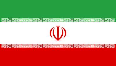
Flag of Iran 


State emblem of Iran (coat of arms adopted 1979)
State emblem of Iran
(coat of arms adopted 1979)


Introduction of Iran

Iran, also known as Persia and officially the Islamic Republic of Iran, is a country located in Western Asia. 

In 1501, the kings, or shahs, of the Safavid Empire began their reign. In the late 18th century, foreign powers, including Russia and Britain, took control of parts of Persia. In 1921, a Persian army officer named Reza Khan took control and sought to end outside influence. In 1935, he renamed the country Iran. 

It  bordered by Iraq and Turkey to the west, by Azerbaijan and Armenia to the northwest, by the Caspian Sea and Turkmenistan to the north, by Afghanistan and Pakistan to the east, and by the Gulf of Oman and the Persian Gulf to the south.  .  It covers an area of ​​1.64 million square kilometers (0.63 million square miles), making it the 17th-largest country.  Iran has an estimated population of 86.8 million, making it the 17th-most populous country in the world, and the second-largest in the Middle East.  Its largest cities, in descending order, are the capital Tehran, Mashhad, Isfahan, Karaj, Shiraz, and Tabriz.


Legislative body

Unlike other Western or Islamic governments, the government of the Islamic Republic of Iran is supervised by a supreme leader and an appointed & unelected Guardian Council which is made up of Islamic clerics, (in the case of the Guardian Council, half of its members are  Islamic jurists).


State heads

The Supreme Leader is the head of state (above the president), and he either has direct or indirect control of the executive, legislative and judicial branches of government, as well as the military and the media.  Iran's president, a parliament (or a Majlis), an Assembly of Experts (which elects the supreme leader), and local councils are all elected, but all candidates who run for these positions must be vetted by the Guardian Council (which disqualifies the overwhelming  majority of the candidates) for their loyalty to the Islamic Republic's system of government. In 1998, the Guardian Council rejected Hadi Khamenei's candidacy for a seat in the Assembly of Experts for "insufficient theological qualifications". In addition, there are representatives elected from appointed organizations (usually under the Supreme Leader's control) to "protect the state's Islamic character".

Capital of Iran 

Tehran is the capital of Iran.


Largest city 

Tehran is the largest city and capital of Iran.


Currancy of Iran

Currancy of Iran is Iranian rial (ریال)(IRR).


Country codes

Caling code +98

Iso code 3166 IR

ISO 3166 is a standard published by the International Organization for Standardization (ISO) that defines codes for the names of countries, dependent territories, special areas of geographical interest, and their principal subdivisions (e.g., provinces or states).


National Language of Iran

National Language of Iran is Persian ( فارسی ) .

Other ethnic regional languages are spoken like 53% Persian, 18% Azerbaijani and other Turkic dialects (incl. Qashqai, Turkmen), 10% Kurdish, 7% Gilak and Mazanderani, 6% Luri, 2% Balochi, 2% Arabic, 2% other (incl. Armenian, Assyrian, Georgian, Laki, Semnani)  Talysh, Tati) are spoken different areas of the Iran.


Time zone

UTC+3:30(IRST)

Coordinated Universal Time or UTC is the primary time standard by which the world regulates clocks and time.


Date format 

yyyy/mm/dd   (SH: Solar Hijri Calender)


Driving side

Right drive


Travel facilities

Transporter vechiels are available in whole Pakistan, trains and domestic air lines are available for some major cities. And boats are available for some water lock areas.


GDP year 2022

Gross Domestic products of the year 2022 is 231.55 US billion dollars.


Relegion

Shia islam 

0.1% others


Population of Iran

It is the world's 17th populous country, and second-largest in the Middle East with a population of almost 86.8 million people, according to census 2022.
It is the fourth-largest country entirely in Asia and the second-largest country in Western Asia behind Saudi Arabia.

Map of Iran 


Map of Iran

Map of Iran 

Total Area

1,648,195 km square .
Water % 1.63 .

Area and boundaries of Pakistan 

Iran has an area of ​​1,648,195 km2 (636,372 sq mi). It is the fourth-largest country entirely in Asia and the second-largest country in Western Asia behind Saudi Arabia. It lies between latitudes 24° and 40° N, and longitudes 44° and 64° E. It is bordered to the northwest by Armenia (35 km or 22 mi), the Azeri exclave of Nakhchivan (179 km or 111 mi), and the Republic of Azerbaijan (611 km or 380 mi);  to the north by the Caspian Sea;  to the northeast by Turkmenistan (992 km or 616 mi);  to the east by Afghanistan (936 km or 582 mi) and Pakistan (909 km or 565 mi);  to the south by the Persian Gulf and the Gulf of Oman;  and to the west by Iraq (1,458 km or 906 mi) and Turkey (499 km or 310 mi).


Cultural civilization and Heritage

The country is home to one of the world's oldest civilizations, beginning with the formation of the Elamite kingdoms in the fourth millennium BC. It was first unified by the Medes, an ancient Iranian people, in the seventh century BC, and reached its territorial height in the sixth century BC, when Cyrus the Great founded the Achaemenid Persian Empire, which became one of the largest empires in history and a superpower. The Achaemenid Empire fell to Alexander the Great in the fourth century BC and was subsequently divided into several Hellenistic states. An Iranian rebellion established the Parthian Empire in the third century BC, which was succeeded in the third century AD by the Sassanid Empire, a major world power for the next four centuries. Arab Muslims conquered the empire in the seventh century AD, which led to the Islamization of Iran. It subsequently became a major center of Islamic culture and learning, with its art, literature, philosophy, and architecture spreading across the Muslim world and beyond during the Islamic Golden Age. Over the next two centuries, a series of native Iranian Muslim dynasties emerged before the Seljuk Turks and the Mongols conquered the region. In the 15th century, the native Safavids re-established a unified Iranian state and national identity, and converted the country to Shia Islam. Under the reign of Nader Shah in the 18th century, Iran presided over the most powerful military in the world, though by the 19th century, a series of conflicts with the Russian Empire led to significant territorial losses.

Iran is rich in cultural civilization and Heritage every years millions of Muslims  visit iran for visiting  their spiritual places.


National of Iran

Pakistani-state owned is known as National of Pakistan. Some important are given below.
  • The colours of the Iranian flag are traditional, probably dating from at least the 18th century, and they can be interpreted as representing the Islamic religion (green), peace (white), and courage (red). National emblem in center of flag and 11 time takbibir line strip in between flag.
  • National language of Iran is Persian.
  • National emblem of Iran is takbibir in center.
  • National hero of Iran is Nader Shah.
  • National supreme leadr of iran is the Ayatollah Sayyid Ali Khamenei .
  • National poet of Iran is Simin Behbahani.
  • National dress of Iran is Lur Traditional Dress (traditional clothes).
  • National mosque of Iran is the Shah mosque , Tehran.
  • National mountain of Iran is Mount Damavand.
  • National River of Iran is Haraz river.
  • National aquatc animal is not yet define their are 155 species of fishes present in Iran.
  • National sport of Iran is wrestling.
  • National flower of Iran is water lily.
  • National animal of Iran is Lion or Panthera.
  • National bird of Iran is Nightingale.
  • National Library and Archives of Iran (NLAI) or National Library of the Islamic Republic of Iran is located in Tehran, Iran.
  • National Fruit of Iran is Pomegranate.
  • National tree of Iran is common name Mediterranean cypress and Scientific name is Cupressus sempervirens.
  • National drink of Iran is Tea.
  • National food of Iran is Khoresh-e ghormeh sabzi.
  • Iran Air is the national airline of Iran.
  • National broadcasting of Iran is The Islamic Republic of Iran Broadcasting (IRIB) is the soleIranian public service broadcaster headquartered in Tehran.
  • National telecommunications of Iran is Telecommunication Company of Iran, or TCI (Persian: شرکت مخابرات ایران, romanized: Sherkat-e Moxaberat-e Iran).
  • National public broadcaster for radio in iran is Islamic Republic of Iran Broadcasting (IRIB).
  • National steel mill of Iran is national Iranian steel company (NISCO).
  • The Islamic Republic of Iran Railways (abbreviated as IRIR, or sometimes as RAI) (Persian: راه‌آهن جمهوری اسلامی ایران, romanized: Râhâhan-e Jomhuri-ye Eslâmi-ye Irân) is the national state-owned railway system of Iran. 
  • National post of Iran is Iran post.


25 April 2023

Pakistan


Pakistan
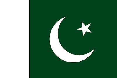
Flag of Pakistan 


State emblem of Pakistan (coat of arms adopted 1954)

State emblem of Pakistan
(coat of arms adopted 1954) 


Introduction of Pakistan 

Pakistan (Urdu: پاکستان ) officially the Islamic Republic of Pakistan is a country in South Asia. Pakistan came into being in 14 Agust 1947.

The founder of Pakistan was Quaied-E-Azam Mohammed Ali Jinnah.

Pakistan is a middle power nation, and has the world's sixth-largest standing armed forces. It is a declared nuclear-weapons state, in 28 may 1998. A nuclear scientist Dr Abdull Qadier khan known as the Father of Pakistani atomic bomb.

Pakistan is ranked among the emerging and growth-leading economies,

But now these days due to cruption and  political crisis Pakistan is on vage of bank rupcy.


Legislative body of Pakistan

The Parliament of Pakistan (Urdu: مجلسِ شوریٰ پاکستان, Majlis-e-Shūrā Pākistān, lit. "Pakistan Advisory Council" or "Pakistan Consultative Assembly") is the federal and supreme legislative body of Pakistan. It is a bicameral federal legislature that consists of the Senate as the upper house and the National Assembly as the lower house.


State heads

The prime minister of Pakistan (Urdu: وزِیرِ اعظم پاکستان , is the head of government of the Islamic Republic of Pakistan. Executive authority is vested in the prime minister and his chosen cabinet, despite the president of Pakistan serving as the nominal head of executive.


Capital of Pakistan 

Islmabad is the capital of Pakistan.


Largest city 

Karchi is the largest city of Pakistan and finical centre.


Currancy of Pakistan

Currancy of Pakistan is Pakistani Rupees.


Country codes

Caling code +92

Iso code 3166 Pk

ISO 3166 is a standard published by the International Organization for Standardization (ISO) that defines codes for the names of countries, dependent territories, special areas of geographical interest, and their principal subdivisions (e.g., provinces or states).


National Language of Pakistan 

National Language of Pakistan is urdu ( اُردو ) but most of official work done in English instead of urdu.

Other ethnic languages are spoken like Pashto, punjabi, saraiki , Sindhi, hindko balochi marathi Kashmiri gujri etc, approximately 77 ethnic languages are spoken all over the Pakistan.


Time zone

UTC+05:00(PKT)

Coordinated Universal Time or UTC is the primary time standard by which the world regulates clocks and time.


Date format 

dd.mm.yy.y.y


Driving side

Left drive 


Travel facilities

Transporter vechiels are available in whole Pakistan, trains and domestic air lines are available for some major cities. And boats are available for some water lock areas.


GDP year 2022

Gross Domestic products of the year 2022 is 376.49 US billion dollars.


Relegion

96.5% islam 

2.1% Hinduism

1.3 % christainty 

0.1% others


Population of Pakistan 

It is the world's fifth-most populous country, with a population of almost 243 million people, according to census 2022 and has the world's second-largest Muslim population, just behind Indonesia.


Map of Pakistan


Map of Pakistan
Map of Pakistan 

Total Area

881,913 km square .
Water % 2.86 .

Area and boundaries of Pakistan 

Pakistan is the 33rd-largest country in the world by area and the second-largest in South Asia, spanning 881,913 square kilometers (340,509 square miles).  It has a 1,046-kilometer (650-mile) coastline along the Arabian Sea and Gulf of Oman in the south, and is bordered by India to the east, Afghanistan to the west, Iran to the southwest, and China to the northeast.  It is separated narrowly from Tajikistan by Afghanistan's Wakhan Corridor in the north, and also shares a maritime border with Oman.  Islamabad is the nation's capital, while Karachi is its largest city and financial center.


Cultural civilization and Heritage

Pakistan is the site of several ancient cultures, including the 8,500-year-old Neolithic site of Mehrgarh in Balochistan, the Indus Valley civilization of the Bronze Age, the most extensive of the civilizations of Afro-Eurasia, and the ancient Gandhara civilization. 

The regions that comprise the modern state of Pakistan were the realm of multiple empires and dynasties, including the Achaemenid, the Maurya, the Kushan, the Gupta; the Umayyad Caliphate in its southern regions, the Samma, the Hindu Shahis, the  Shah Miris, the Ghaznavids, the Delhi Sultanate, the Mughals, and most recently, the British Raj from 1858 to 1947.


National of Pakistan 

Pakistani-state owned is known as National of Pakistan. Some important are given below.
  • National flag of Pakistan having green and white color Cresent and star ,green represents the Muslim majority and agricultural country white non Muslims and sighn of peace.
  • National language of Pakistan is Urdu.
  • National emblem of Pakistan is shield with wreath of jasmine.
  • National motive of Pakistan Faith, Unity, Discipline.
  • National badges of Pakistan is Nishan-e-Haider , Tamgha-e-Imtiaz.
  • National heros of Pakistan is Quaied-e-Azam Mohammed Ali Jinnah and Fatima Jinnah.
  • National mausoleum of Pakistan is Mazar-e-Quaied.
  • National poet of Pakistan is Allama Iqbal.
  • National Mohsin of Pakistan is Dr. Abdul Qadier khan.
  • National dress of Pakistan is shalwar kameez.
  • National colure of Pakistan is dark green.
  • National mosque of Pakistan is Faisal mosque, Islmabad.
  • National mountain of Pakistan is K-2.
  • National River of Pakistan is indus river.
  • National aquatc animal of Pakistan is indus river dolphin.
  • National sport of Pakistan is Hockey.
  • National flower of Pakistan is Jasmine.
  • National animal of Pakistan is Markhor.
  • National bird of Pakistan is chukar (chukar partridge).
  • National library of Pakistan is National library Islmabad.
  • National Fruit of Pakistan is Mango.
  • National vegetable of Pakistan is lady finger.
  • National tree of Pakistan Deodar tree.
  • National drink of Pakistan is sugarcane drink.
  • National food of Pakistan is Nihari.
  • National broadcasting of Pakistan is Pakistan television (ptv) established in 1964.
  • National telecommunications of Pakistan is Pakistan telecommunication company limited (Ptcl), established since 1947.
  • National public broadcaster for radio in Pakistan is Radio Pakistan head quarter is in Islamabad. The network established in 14 agust 1947.
  • National steel mill of Pakistan is Pakistan steel mill Karachi.
  • Pakistan Railways (reporting mark PR) (Urdu: پاکستان رلویز) is the national, state-owned railway company of Pakistan head office in Lahore.
  • National Air line of Pakistan is Pakistan international airline (PIA).
  • National post of Pakistan is Pakistan post established in 1947, it started functioning as Department of Post & Telegraph head office in Islamabad.


Pagination:

1 2 3 4 5 6 7 8 9 10 11 12